網上版請按此
Esri Young Scholars Award shows severe noise pollution in old districts
To build a people-oriented liveable city, urban planning is one of the key areas while Geographic Information System (GIS) application is an indispensable tool. GIS links data and geographic distributions to allow people to grasp the overall situation and thus help find suitable solutions.
Esri, a US GIS software company, organizes an Esri Young Scholars Award to encourage students around the world to use GIS to study and think about different challenges facing a city, like education, conservation, disaster relief, urban planning, business and engineering and so on.
The competition was first organized in 2012 with students from Canada, Germany, Spain, the Netherlands, Norway, Russia, Ghana, South Korea, China, Japan and Kuwait participating.
For example, Shun Kawakubo, a graduate student of the Keio University in Japan, assessed the sustainability of municipalities in Japan from the perspective of the environment, society and economy, hoping that government planning will put more emphasis on building a sustainable future.
Paulina Ansaa Asante from the University of Ghana performed a site suitability analysis for a central wastewater treatment plant in the Accra Metropolitan Area. She analyzed numerous variables, such as elevation, distance to surface water bodies, land cover, distance to major roads, airport facilities, and existing populated communities, then put forward a feasible and optimal solution.
Last year, a Finnish winner, Aapeli Leminen, worked on the time and cost incurred by a patient with type 2 diabetes. The World Health Organization estimated that by 2030, diabetes will become the world’s No. 7 killer. Leminen’s study found that the transportation cost for patient’s consultation accounted for over 20 percent of the total medical expense. The older the patient, the higher the expense as taxi instead of bus may be needed. He hopes that the study will promote the development of local self-service medical system to relieve the fatigue of both patients and caregivers while reducing related expenses.
This year, Hong Kong launched a competition which attracted a lot of contestants. The themes of the projects varied from leisure space analysis, Tanzania mineral exploration, traffic routes within campus to light pollution, etc. The judges consisted of local distinguished scholars and industry gurus.
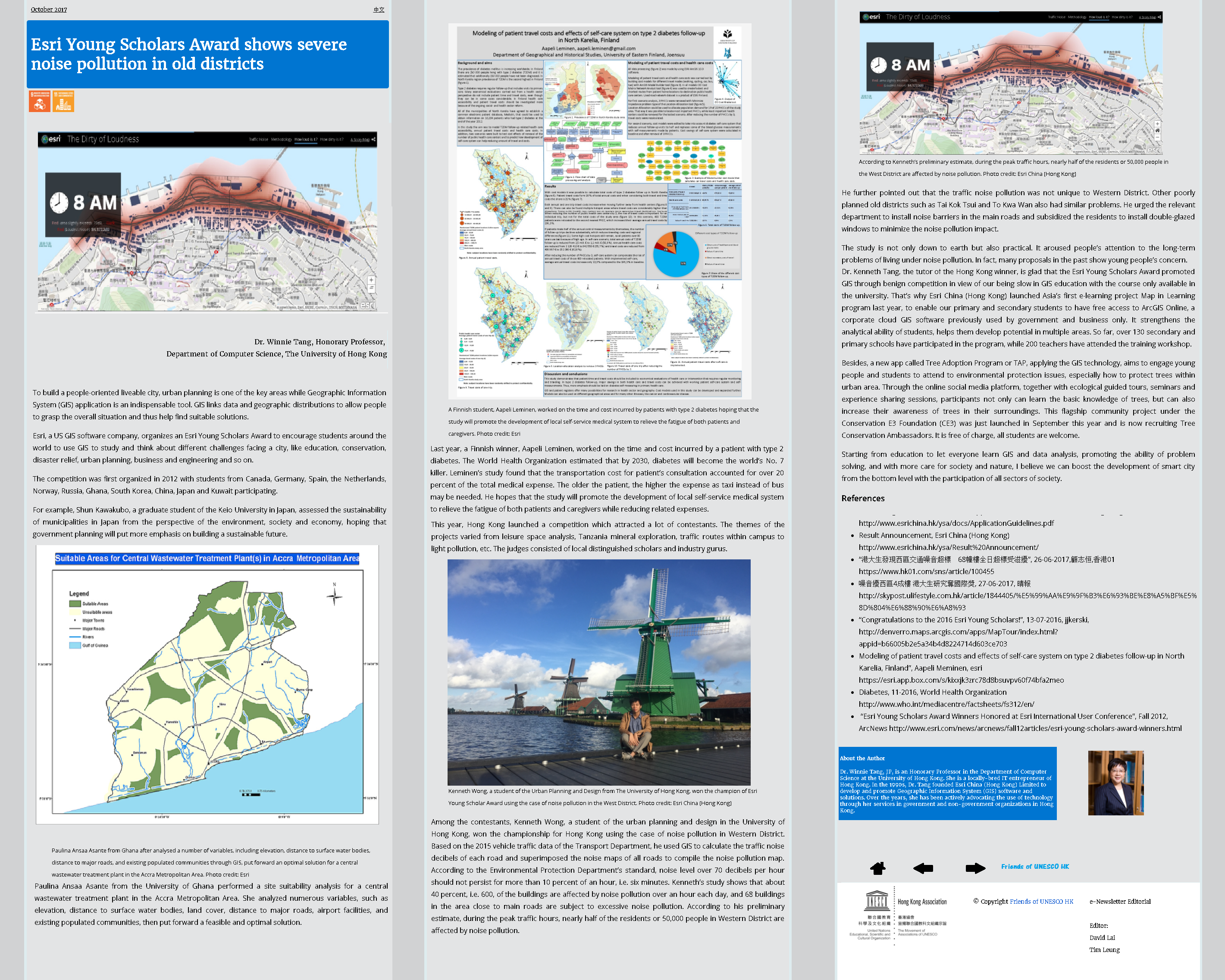
Among the contestants, Kenneth Wong, a student of the urban planning and design in the University of Hong Kong, won the championship for Hong Kong using the case of noise pollution in Western District. Based on the 2015 vehicle traffic data of the Transport Department, he used GIS to calculate the traffic noise decibels of each road and superimposed the noise maps of all roads to compile the noise pollution map. According to the Environmental Protection Department’s standard, noise level over 70 decibels per hour should not persist for more than 10 percent of an hour, i.e. six minutes. Kenneth’s study shows that about 40 percent, i.e. 600, of the buildings are affected by noise pollution over an hour each day, and 68 buildings in the area close to main roads are subject to excessive noise pollution. According to his preliminary estimate, during the peak traffic hours, nearly half of the residents or 50,000 people in Western District are affected by noise pollution.
He further pointed out that the traffic noise pollution was not unique to Western District. Other poorly planned old districts such as Tai Kok Tsui and To Kwa Wan also had similar problems. He urged the relevant department to install noise barriers in the main roads and subsidized the residents to install double-glazed windows to minimize the noise pollution impact.
The study is not only down to earth but also practical. It aroused people’s attention to the long-term problems of living under noise pollution. In fact, many proposals in the past show young people’s concern.
Dr. Kenneth Tang, the tutor of the Hong Kong winner, is glad that the Esri Young Scholars Award promoted GIS through benign competition in view of our being slow in GIS education with the course only available in the university. That’s why Esri China (Hong Kong) launched Asia’s first e-learning project Map in Learning program last year, to enable our primary and secondary students to have free access to ArcGIS Online, a corporate cloud GIS software previously used by government and business only. It strengthens the analytical ability of students, helps them develop potential in multiple areas. So far, over 130 secondary and primary schools have participated in the program, while 200 teachers have attended the training workshop.
Besides, a new app called Tree Adoption Program or TAP, applying the GIS technology, aims to engage young people and students to attend to environmental protection issues, especially how to protect trees within urban area. Through the online social media platform, together with ecological guided tours, seminars and experience sharing sessions, participants not only can learn the basic knowledge of trees, but can also increase their awareness of trees in their surroundings. This flagship community project under the Conservation E3 Foundation (CE3) was just launched in September this year and is now recruiting Tree Conservation Ambassadors. It is free of charge, all students are welcome.
Starting from education to let everyone learn GIS and data analysis, promoting the ability of problem solving, and with more care for society and nature, I believe we can boost the development of smart city from the bottom level with the participation of all sectors of society.
Dr. Winnie Tang, Honorary Professor,
Department of Computer Science, The University of Hong Kong