網上版請按此
How to optimise land use in redeveloping old districts
As mentioned in the previous article, the redevelopment project of the Urban Renewal Authority (URA) in Kim Shin Lane of Sham Shui Po includes 90 nine-storey buildings over 50 years old. The major problems encountered include resettling a large number of households, a substantial reduction in usable floor area due to today's planning regulations.
To break through the predicament, it is necessary to abandon the previous approach of treating the project as a single isolated redevelopment plan, and to examine it from a macroscopic urban renewal perspective, so that the land can be effectively integrated with the surrounding areas and fully utilized. This kind of planning-led thinking allows the scattered small parks, playgrounds, and stadium that have been there for over 40 years to be collectively re-designed to increase greening and recreational space in the area, benefiting the entire community. The innovation of this redevelopment plan is to cross Cheung Sha Wan Road and use the land surrounding Sham Shui Po Sports Ground to relocate parks and playgrounds with the concept of Single Site Multiple Use, so as to build more advanced recreational and sports facilities. Meanwhile, this provides a chance to construct facilities for residents in the old district to cross Cheung Sha Wan Road, and to readily access the Sham Shui Po Sports Ground, connecting the old district with the new district.
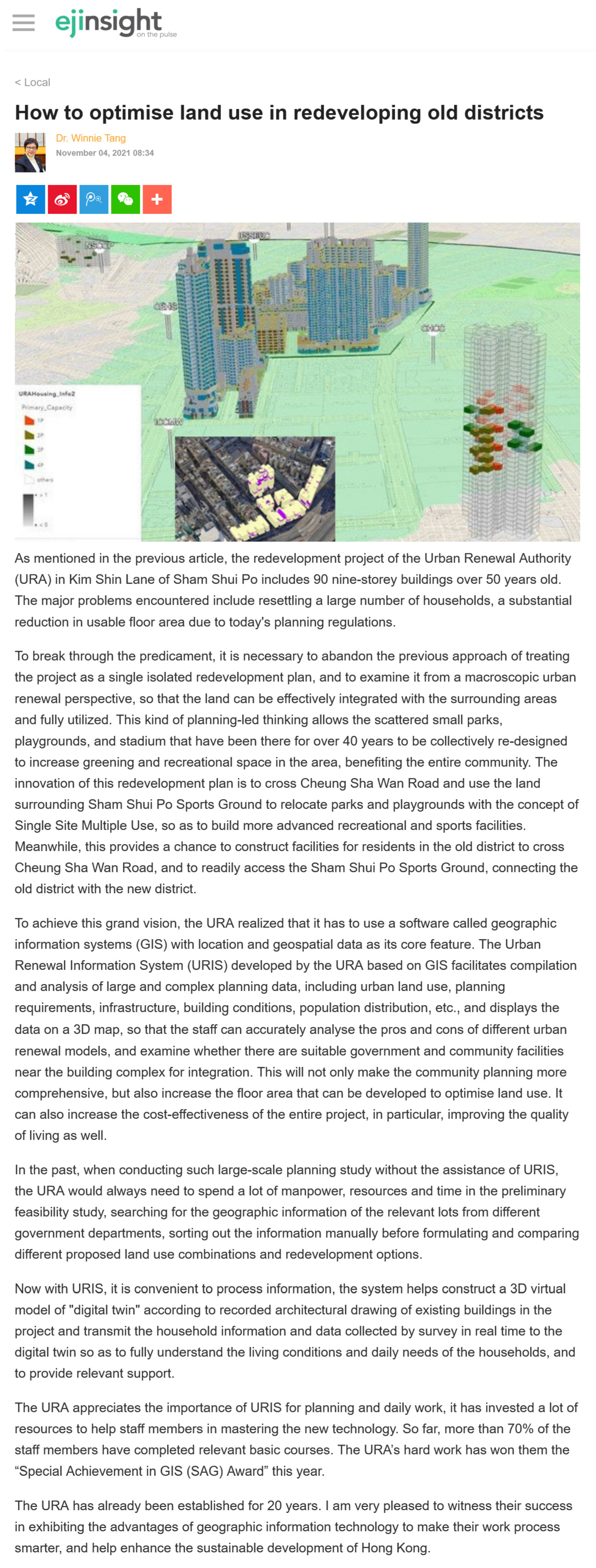
To achieve this grand vision, the URA realized that it has to use a software called geographic information systems (GIS) with location and geospatial data as its core feature. The Urban Renewal Information System (URIS) developed by the URA based on GIS facilitates compilation and analysis of large and complex planning data, including urban land use, planning requirements, infrastructure, building conditions, population distribution, etc., and displays the data on a 3D map, so that the staff can accurately analyse the pros and cons of different urban renewal models, and examine whether there are suitable government and community facilities near the building complex for integration. This will not only make the community planning more comprehensive, but also increase the floor area that can be developed to optimise land use. It can also increase the cost-effectiveness of the entire project, in particular, improving the quality of living as well.
In the past, when conducting such large-scale planning study without the assistance of URIS, the URA would always need to spend a lot of manpower, resources and time in the preliminary feasibility study, searching for the geographic information of the relevant lots from different government departments, sorting out the information manually before formulating and comparing different proposed land use combinations and redevelopment options.
Now with URIS, it is convenient to process information, the system helps construct a 3D virtual model of "digital twin" according to recorded architectural drawing of existing buildings in the project and transmit the household information and data collected by survey in real time to the digital twin so as to fully understand the living conditions and daily needs of the households, and to provide relevant support.
The URA appreciates the importance of URIS for planning and daily work, it has invested a lot of resources to help staff members in mastering the new technology. So far, more than 70% of the staff members have completed relevant basic courses. The URA’s hard work has won them the "Special Achievement in GIS (SAG) Award" this year.
The URA has already been established for 20 years. I am very pleased to witness their success in exhibiting the advantages of geographic information technology to make their work process smarter, and help enhance the sustainable development of Hong Kong.
Dr. Winnie Tang
Adjunct Professor, Department of Computer Science, Faculty of Engineering; Department of Geography, Faculty of Social Sciences; and Faculty of Architecture, The University of Hong Kong