網上版請按此
How 3D spatial information brings people closer to nature
The annual Esri Young Scholars Award provides an opportunity for local university students to conduct research in their chosen topics using the geographic information system (GlS). The champion can participate for free in the Esri User Conference held in the United States in July to exchange knowledge and experiences with more than 10,000 GIS experts around the world. The champion, first runner-up and second runner-up will also win an internship for working at the Urban Renewal Authority, same as previous years.
When I saw their award-winning works, I can't help admiring the young people's broad visions, care for society and creative thinking.
This year's champion, first runner-up and second runner-up are all students from the Department of Urban Planning and Design, Faculty of Architecture, the University of Hong Kong. Their research topics focus on quality of living and mobility that are closely related to us. The students analysed the problems with new perspectives and new data, which is very impressive.
The champion is Li Maosu, Eric. He studied how urban housing planning can bring people closer to nature.
Li quoted a number of studies, saying that being close to nature, be it the sea, sky, trees, in a city park or in the countryside, is of great benefit to people's mental health and productivity. However, even if you live in the same building, the view out from a window at 30/F is quite different to that from a window at 2/F. If you can't see the natural scenery through the window of your home, is there a place for walking, jogging or hiking nearby? If none of the above is available, the authority should work hard on urban planning for that building.
Li chose 314 residential buildings in 43 town blocks in Wan Chai as the research sub-object, covering Lockhart Road, Fleming Road, Jaffe Road, and Johnston Road. Within the area, there are many old buildings in mix with 30 to 40-storey new buildings, which block the views of the old buildings. So how to perceive the natural views of every unit on different floors of each building?
In recent years, the government has opened the 3D Pedestrian Network and 3D Visualisation Map datasets to the public for free. The new data makes it possible for people to analyse urban problems with enriched elements.
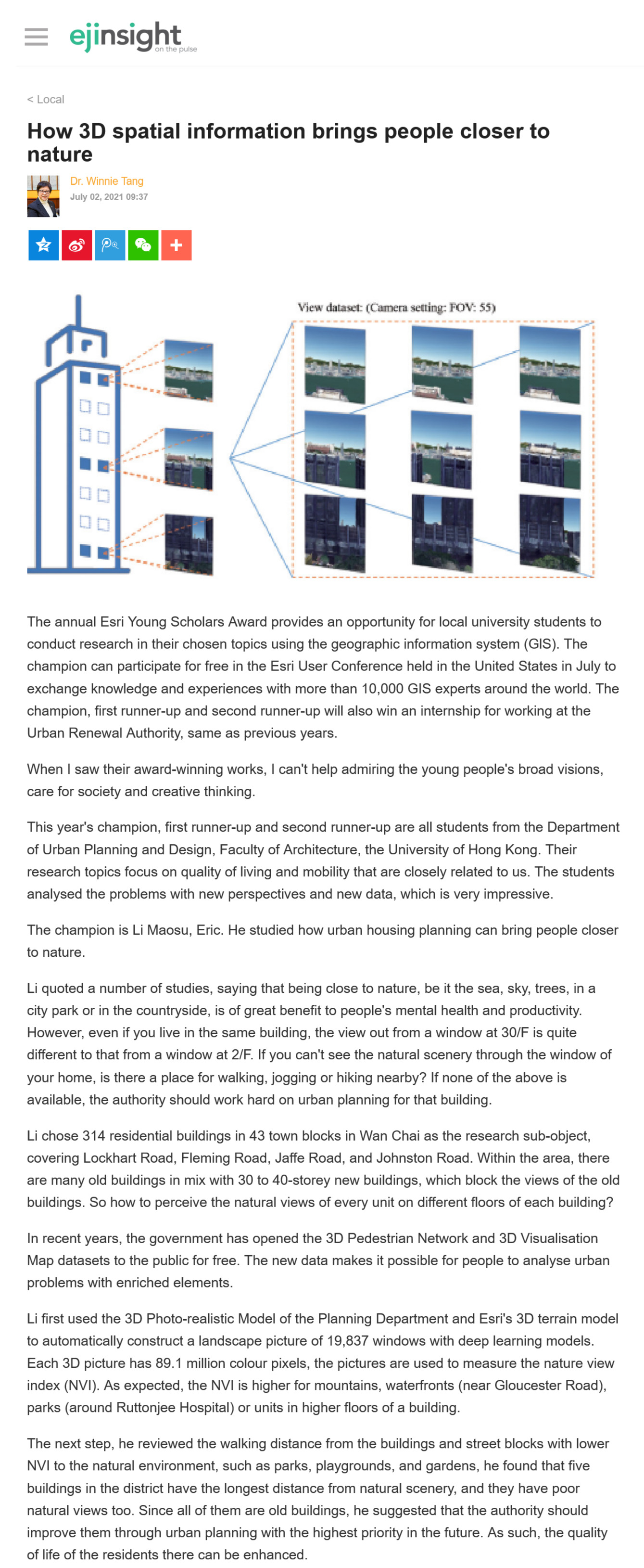
Li first used the 3D Photo-realistic Model of the Planning Department and Esri's 3D terrain model to automatically construct a landscape picture of 19,837 windows with deep learning models. Each 3D picture has 89.1 million colour pixels, the pictures are used to measure the nature view index (NVI). As expected, the NVI is higher for mountains, waterfronts (near Gloucester Road), parks (around Ruttonjee Hospital) or units in higher floors of a building.
The next step, he reviewed the walking distance from the buildings and street blocks with lower NVI to the natural environment, such as parks, playgrounds, and gardens, he found that five buildings in the district have the longest distance from natural scenery, and they have poor natural views too. Since all of them are old buildings, he suggested that the authority should improve them through urban planning with the highest priority in the future. As such, the quality of life of the residents there can be enhanced.
Dr. Winnie Tang
Adjunct Professor, Department of Computer Science, Faculty of Engineering; Department of Geography, Faculty of Social Sciences; and Faculty of Architecture, The University of Hong Kong